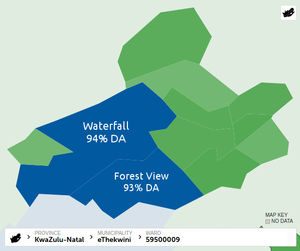
Green is ANC dominated and blue is DA. The first impression one gets when looking at the results for the Upper Highway area in Durban is that it is predominantly ANC run with pockets of DA support. Not unlike most of South Africa and it's what most people have come to expect of South African elections.
One might notice however, that the shape of the ward boundaries here seem a little unusual, the boundaries become more questionable when looking at the larger Ethekwini area where one notices that the Upper Highway wards are generally larger than others. Large wards are usually a sign of outlying areas where the electorate is sparse. But the upper highway area is relatively populous so what's going on here?
If we zoom in to each of those light green wards surrounding the dark blue Kloof ward in the centre, a picture starts emerging of possible deliberate dilution of the DA vote in order to maintain an illusion of ANC dominance in the area. While someone's playing the propaganda game the tax payers in the area are stuck with incompetent ANC councillors. I have no doubt this is happening all over South Africa but this is my neighbourhood so this is what I've been paying close attention to.
Ward 59500009 - Waterfall, Forest View, Crestholme, Molweni
Most of the ward is clearly DA but since Molweni, a large ANC community, was added to this ward it has been ANC run ever since.
Ward 59500008 - Eastern Hillcrest and outlying areas
This is a clear example of abuse of ward designation. There is absolutely no reason for Hillcrest to be included in this ward.
Ward 59500007 - Southern Hillcrest and outlying areas
Why is Hillcrest split up and added to other wards like this? Why not make it a ward of it's own?
Ward 59500103 - Bothas Hill, Drummond, Assagay, Shongweni
A huge, predominantly DA ward with surrounding ANC areas added to it.
Ward 59500015 - Southern Kloof, Westmead
Another example of a community being split up for political reasons.
Ward 59500019 - Eastern Kloof, Wyebank
An example of a ward being stretched as far as possible to maximise dilution.
Ward 59500021 - Pinetown, New Germany
An example of two separate communities being merged.
Ward 59500016 - Southern Pinetown
Again, clear ward boundary manipulation.
When all the districts are stitched together over the wards, one can clearly see the actual community lines along which ward boundaries should be defined. And when we look at Ethekwini (Durban) as a whole you can see just how big of an impact this ward manipulation can have.
Bear in mind that I've only been looking at the Upper Highway area. If someone were to do the full investigation I suspect that they'd find huge support for DA all over the country that's being hidden by diluting DA districts into ANC dominated wards.
Data is sourced from the IEC via News24.com. Please go check out News24's comprehensive election map for more detailed and up to date election data.


Comments
Post a Comment